
Discovering Distribution Centers Surrounded by Nature on the 9 Creeks Loop, Segment 2
The 9 Creeks Loop is a 42-mile hike that physically circles the city of Denver on trail. It uses a combination of 4 regional trails to lap the city. This urban hiking series has broken the 42 miles into 8 easy ~5 mile segments that are flat, have easy-to-find trailheads and trail ends, and all can be walked in any direction. Transit is mostly available to the trailheads, although you may need to be a bit creative. When I walk the loop, I often will take a Lyft. You can certainly walk the segments as out-n-backs as well.
Note: In Summer 2020, the Stapleton residents renamed their neighborhood to Central Park.
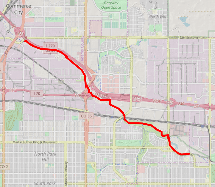
9 Creeks Loop Segment 2 Mile 5-10
Trailhead: Dahlia Trailhead (4900 Sandcreek Dr S, Commerce City, CO 80022)
Trailend: Bluff Lake Nature Center (11255 E M.L.K. Jr Blvd, Denver, CO 80238)
Highlights: Central Park (fka Stapleton), Old Stapleton Runway, Central Park, Bluff Lake Nature Center

On segment two, the underpinning story is one of transportation. You’ll be walking through where the old Stapleton airport was, now replaced by the new urban-infill Stapleton neighborhood. But despite the growth of residences and the supporting businesses, this area along the Sand Creek was first developed as a transit zone. You’ll see the impact of i25, i70, i270, and i76 all coming together along with the trains and supporting road systems, as this area was once the major distribution point for western commerce. Some might argue that it still is, as you might smell the products Purina, Safeway, and Cape Cod Chips. None the less, you’ll quickly leave the hustle and bustle of transit’s heartbeat and end up passing urban farms and preserves on your way to Bluff Lake Nature Center.
To see footage of this mile, watch this video.
Start by Enjoying the Tranquility of Sand Creek

Hop back on the Sand Creek trail at the Dahlia trailhead and go east (left). You will walk mostly a straight route along the Sand Creek with i270 on your left. Due to the interesting rock retaining wall, you’ll barely notice the interstate. Focus on the creek and its wildlife as you make your way under some overpasses and train trestles.
To see footage of this mile, watch this video.
Continue under Major Roads and Interstates

You’ll cross over Sand Creek and going to your left, making a large loop under Quebec Street. At the T in the trail, stay to your left, going under i70 and then crossing the pedestrian bridge. At this point, the trail turns to pebble trail and makes a Z shape on the way to Central Park Blvd. Cross under Central Park on the new concrete trail. (Please note that there may be construction in the area. Please follow detour signs if necessary.)
Unfortunately, you might also pass several people experiencing homelessness. Although the Sand Creek Greenway does a great job at assisting the homeless into shelters, you may stumble upon them if you journey this way.
Watch the video of this area of Stapleton here.

And then You’ll Find the Old Stapleton Airport
Once you reach the concrete trail, you will settle into a nice straight walk for about a mile. The Sand Creek will be on our right. After about half of a mile, you’ll notice concrete walls along the banks of the waterway. At one time, the Stapleton airport runways crossed here on a bridge built for the airplanes. You can find old pictures of planes taxiing on the bridge. It was here.

After passing through the old runways, you will continue along and come to the Sand Creek trailhead off Smith Road. On the left, you will see a large parking lot, a bench, and a port-a-potty. There is some interpretation of the fauna in the area. After taking a break, continue east along the Trail. To the south, you will start seeing homes and then come across Central Park.

Listen to the video of the History of Stapleton.

From Runways to Running Paths
Stapleton International Airport started in 1919 as an airfield and became the Denver Municipal Airport in 1929. The Central Park neighborhood is the ingenuousness of an urban redesign. In 1995, Stapleton airport closed due to noise and size, and the Denver International Airport was built about 15 miles north. Forest City Enterprises won the rights to redevelop the old airport into a community designed for walking, green spaces, and families. The transformation of 7.5 square miles of runways, concourses, and terminals into a beautiful new community was the largest urban in-fill redevelopment in the country and one of the largest in-fill projects ever. The south side of Stapleton has about 15,000 homes, and the Northfield area, on the north side of I-70, has an open-air shopping plaza and will have as many homes. The Sand Creek Greenway attempts to connect the two sides of Central Park.

Passing the Urban Farm, Next Up Is the old Crash Landing Site
You’ll approach Havana and be a bit at a loss for how to get across the creek and continue on the Trail. You’ll need to go up to Havana and cross on the sidewalk bridge to the south. Continue along the street until you get to the intersection with the light. You’ll see apartments on your right. Cross the street, then continue on the Sand Creek Greenway to the right. Don’t be fooled by going to the left, as the Trail does not follow the Creek here. Continue along the Trail as it runs parallel to the road with Bluff Lake on your left and the road on your right. Prairie dogs will probably bark directions to you as you walk by. (Alternatively, you could enter the north end of Bluff Lake Nature Center and hike through the Center to reach this segment’s end.)
Listen to the video about Denver Urban Farms and Stapleton’s Central Park.

You’ll arrive at the end of 9 Creeks Loop Segment 2, Bluff Lake Nature Center. A local get-away, this quaint Reserve not only has a nice place to take a break and use a port-a-potty, but if you have time and interest, you can definitely take the steps down into the Reserve and explore the local flora and fauna (f you didn’t take the alternate route through Bluff Lake.) Check the Center’s calendar for seasonal events. An interesting note about the Nature Center–when it was being built, they used the old runway concrete from the Stapleton airport. Volunteers called the rock, Staple-Rock. Bluff Lake was the original crash landing site for the airport!
Watch the video about Bluff Lake here.
Click here to read about the next segment, segment 3, 9 Creeks Loop Mile 10-15.
Walking the 9 Creeks Loop and Denver By Foot
 You can find more information about the 9 Creeks Loop here. I have also written about it extensively in my book, The Best Urban Hikes: Denver.
If you’ve enjoyed this walk, maybe you’ll enjoy some other walks curated by Denver By Foot. Get the 52 Hikes 52 Weeks Denver Calendar, which recommends a hike a week, subscribe to the YouTube Channel to hear about weekly hiking suggestions in Denver, and buy access to the Denver By Foot Challenge. The Challenge is 30 activities in Denver to do by foot where you’ll uncover treasures throughout Denver. It’s a great thing to do with friends and family.
Finally, please support Denver By Foot by purchasing Chris Englert’s books, The Best Urban Hikes: Denver and Discovering Denver Parks. Thank you so much!