
No Bears on Bear Valley Urban Hiking Adventure

Walking through Denver neighborhoods in alphabetical order, you’ll learn immediately how the 1965 Denver Flood impacted our city, like the stories in Baker, La Alma/Lincoln and Athmar Park.
Need a great pack? Try an Osprey. The perfect backpack for your next adventure.
In Bear Valley, the flood came through right as the neighborhood started to develop. With split level homes throughout this hilly ‘burb, it seems like everyone was trying to get as far away from Bear Creek (a potential flood creator), which runs on the neighborhood’s south end, as they could. Enjoy this 3.5 mile amble on an Bear Valley urban hiking adventure.
Sharing with Lakewood

Bear Valley’s boundaries don’t quite make a rectangle, as it intermingles with Lakewood on its west side. None the less, the neighborhood’s borders are approximately Yale, Sheriden, Hampden and Bear Creek. Rising up from Bear Creek to the north sits this late 1960s neighborhood full of split-level homes, Ford trucks, and an occasional artsy flair.
A Creek Runs through It

Photo credit Melissa Turner
The Bear Creek runs along the south side of the neighborhood, making its way northwesterly to the Bear Creek Reservoir. The Bear Creek Trail, which runs for just over 9 miles, makes a wonderful getaway to either Morrison on its west end or Englewood on its east end. You’ll see many locals and their dogs enjoying an amble, and you could even witness some federal contractors cleaning out fallen trees from the Creek’s banks.
Need a great pack? Try an Osprey. The perfect backpack for your next adventure.
Along Bear Creek, you’ll want to stop in one of Denver’s most fun parks, Bear Creek Park. Not only will you see great outdoor murals on the restroom building’s walls, but you can also slide down a fun cowboy hat/slide. There’s even a fun cowbow poem embedded into the playground.
Personality Sneaks In

Although not a very descriptive neighborhood, it has friendly neighbors, a suite of schools, and inviting sidewalks. Interesting to note is that their high school, John F Kennedy, was one of the first high schools to implement mandatory, desegregated busing between Lincoln High and Kennedy in 1975. The school also has the only marine biology program in Denver Public Schools.
Bears….
In a place called Bear Valley along Bear Creek Trail, you’d expect to find some Colorado bears. There are approximately 10000-20000 American Black Bears in Colorado, and they can range from brown to honey to cinnamon in color. Although not many are ever found here in the ‘burbs, they do show up in the spring after hibernation season. Never feed a bear or try to pet one. If you see a bear, talk loudly. Make eye contact, and slowly back away from the bear. Do not approach.
I wear these shoes and I get them from REI, where you can return shoes for up to a year.
If you want a solid, hilly, urban hike through an inviting neighborhood with a nice jaunt along the creek, enjoy this 3.5 mile route through the neighborhood, past the schools, and beside the creek.
The route (click for interactive map):
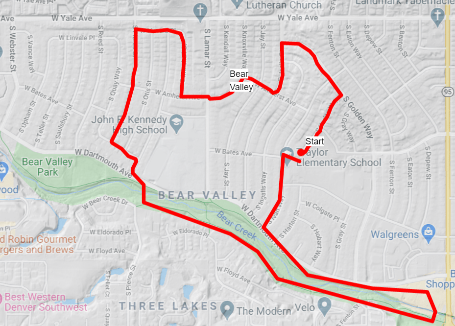
This 3.5 mile route starts at 2898 S Harlan Way. This is a residence. Park along the street. The Bart Hobart Park is across the street, and where you’ll start walking. Head up the hill along the sidewalk through the park to the top of the hill along Harlan Way.
Turn left on South Golden Way. Walk two blocks, turn left on South Joslin Court. Turn right on West Amherst Avenue. Take a left on South Knoxville Way, which turns back into West Amherst Way. At South Marshall Street, take a right, and then at the top of the hill, take a left on West Linvale Place.
Along the way, notice the various artwork in people’s front yards. Some is subtle, and some is fun. Notice the three large metal flowers on Linvale right before you turn left on South Pierce Street.
Continue down Pierce and take a left at the bottom of the hill onto West Cornell Street. Go two blocks and take a right on South Newland Street. Cross West Dartmouth, and take the bridge across Bear Creek, catching the Bear Creek Trail.
Follow the Bear Creek Trail to the left, or east, for about a mile. If you don’t want to walk that far, take the first bridge across the Creek. Or, continue all the way to Sheridan, crossing the Creek north right before Sheridan. Work your way back west through the old WalMart parking lot to West Dartmouth. You’ll see the Bear Creek Trail on your left, paralleling the Creek from whence you came.
I wear these shoes and I get them from REI, where you can return shoes for up to a year.
Continue westerly along the north side of the Creek to South Ivan Way. Cross Dartmouth and take Ivan north. Pass the school, take a right on West Bates Avenue, and then a left onto S Harlan Way, where you will return to the start.
Baring a Fun Hike in Bear Valley and Supporting Denver By Foot
 If you’ve enjoyed this info about the High Line Canal Trail and how to hike it, maybe you’ll enjoy some other walks curated by Denver By Foot. Get the 52 Hikes 52 Weeks Denver Calendar, which recommends a hike a week, subscribe to the YouTube Channel to hear about weekly hiking suggestions in Denver, and buy access to the Denver By Foot Challenge. The Challenge is 30 activities in Denver to do by foot where you’ll uncover treasures throughout Denver. It’s a great thing to do with friends and family, or even along during our lock down.
Finally, please support Denver By Foot by purchasing Chris Englert’s books, The Best Urban Hikes: Denver and Discovering Denver Parks. Thank you so much!
What did you like about this walk? Post it on Facebook and tag your posts with #denverbyfoot so I can find them.
See you on the trail!
~Chris