
5 Shady Walks IN Denver

*note: You can now download an interactive version of this walk at https://www.gpsmycity.com/gps-tour-guides/denver-568.html
Hi everyone. First, I want to start by saying that this article is about Denver. Not Boulder. Not Colorado Springs. Not the Front Range.
I can be a bit of a stickler for Denver. When I mean IN Denver, I mean IN Denver.
The City and County of Denver (including the Denver Mountain Parks.) So when I search and find other people’s recommendations for hikes in Denver, and they take me to Three Sisters, I get a bit annoyed.
Sorry for the rant.
Hiking in Denver
I will admit that “hiking in Denver” is more like walking or urban hiking. Since Denver is flat and most of the trails are concrete, people might argue that there is no hiking in Denver.
ToMAYto ~ ToMAHto.
Point taken.
And I will also admit that finding SHADE in Denver (without being in a park) is also a big challenge. We are, by the way, in the high prairie, and forests don’t come naturally here in the high plains. Thus, the best place to find shady places to walk in Denver would be the parks (Cheesman ((see video)), City Park, Wash Park, and Civic Park are great ones), but if you actually want to get some distance and feel like you’re hiking in Denver in the shade, you’ll need to be a bit creative.
So, with apologies to people who might not be as much of a stickler for IN Denver as I am, here are my 5 recommendations for where to hike in Denver in the shade.
5 Shady Denver Hikes
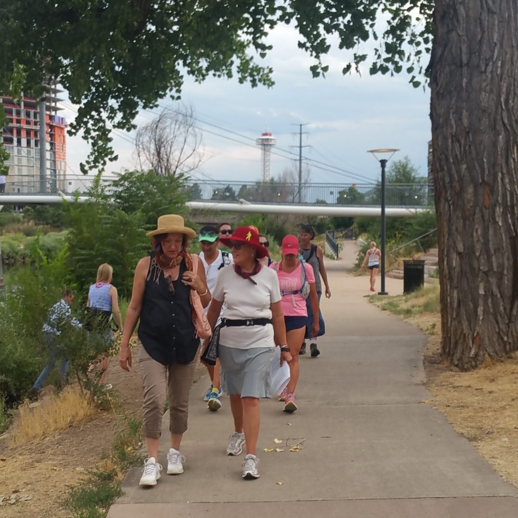
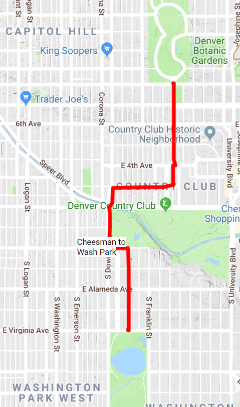
1. Cheesman Park to Washington Park (3 miles)
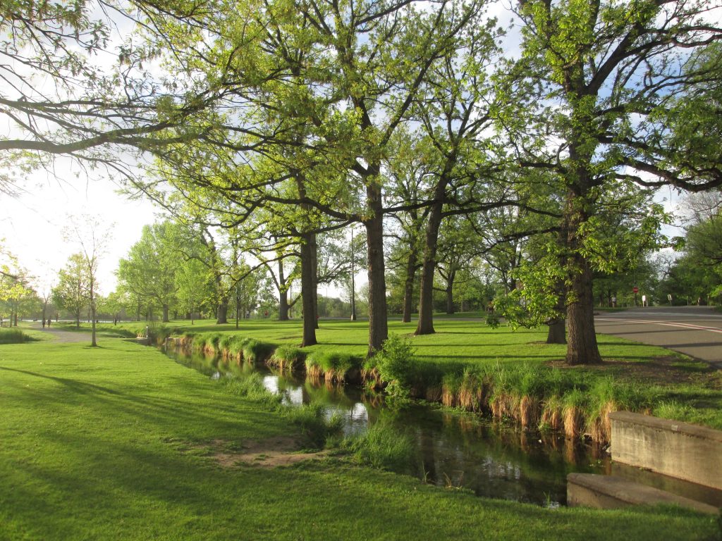
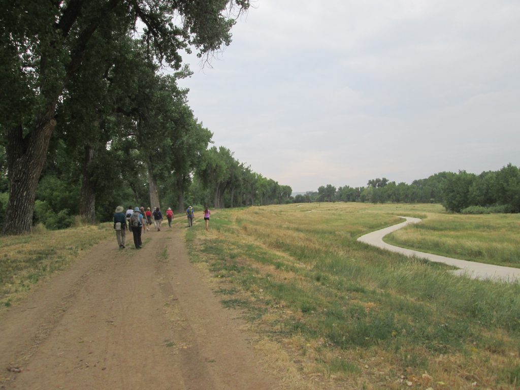
This is a fantastic walk through two landmark parks in Denver, Cheesman, and Wash Parks. Start in Cheesman and explore the Cheesman Memorial and the bronze outline of our Front Range. Then, walk south out of the park through the lush and rich Country Club Park neighborhood.
You’ll pass by giant homes of the Who’s Who in Denver. Due to the limited access to the Country Club Golf Course, you’ll have to route around it via University Blvd. Grin and bear it for a 1/4 mile, then you’ll be back into the Country Club/North Wash Park neighborhoods as you approach Wash Park. Once you get to Wash Park, you can enjoy a 6-mile loop, stopping by its gardens, lakes, art, and sculpture. I share this walk with visiting family during Thanksgiving.
Turn-by-turn directions. To get in six miles, walk back to Cheesman, or if you want to keep the walk shorter at 3 miles, take a ride share (Uber/Lyft)). I recommend starting in Cheesman and exiting the park via its southern end onto Williams St. Continue through Country Club to E 3rd Ave. Take a right to S Downing St., then a left on W Bayoud St. Take a right to S Lafayette St to Wash Park. (click for interactive map)
2. Lakewood/Dry Gulch Lollipop Loop. (2-3.5 miles)
This hike is a fabulous hike through linear parks and along gulches. You’ll be on a paved trail most of the way except for a few streets at the end to complete the loop. Shady, with giant cottonwood trees, has plenty of places to chill along the creek. For a 2-mile loop, take the W light rail to the Knox St Station and follow the loop instructions below. For a 3.5-mile loop, take the W light rail (or park) at the Federal/Decatur Station. Walk west to the Platte River, then return to the station and follow the loop instructions below.
Turn-by-turn directions. If you’ve started at Federal and walked to the Platte, turn around and walk west. Or, if you have begun at Knox station, walk west. (If you have some extra energy, be sure to stop at the mic structure in Paco Park (see video) for some good play time.) Walk west along the Lakewood Dry Gulch Trail. You’ll come to a fork in the trailhead left (southerly) on the Lakewood Gulch Trail through Joseph P Martinez Park (see video). The trail will end at Tennyson Street.
Walk north up Tennyson Street for two blocks, crossing W 10th Ave. Keep going, and you’ll reenter the green space. Continue north to the Lakewood Dry Gulch Trail, and turn right (east). Stay on the concrete path until you return to Knox Station or Federal Station.

 What Shoes to Wear: My favorite summer shoe is a Pair of Closed-toe Chacos.
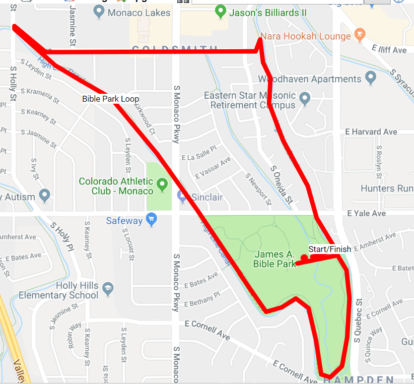
3. The Bible Park Loop (3.5 miles)
This 3.5-mile loop takes advantage of a grand loop around James A Bible Park. The High Line Canal Trail makes a beautiful horseshoe turn around Denver’s gem, providing a ring of cottonwood trees. Look for owl and hawk nests in the canopy. A special treat here is that even though there may not be water from Denver Water running through the canal, you’ll often find water in it due to other sources. The Goldsmith Gulch also runs through the park, providing nooks and crannies to relax in the shade or hunt for tadpoles!
Turn-by-turn directions. Park in Bible Park (see video.) From the parking lot, head east to the park’s perimeter and jump on the High Line Canal Trail. Walk in a southerly direction. The trail will make a sharp horseshoe turn, leading you to the north—Cross E Yale and then Monaco Pkwy. Continue Northwesterly to Iliff Ave. At Iliff, leave the High Line and take the sidewalk to the east (right) until you cross Monaco Pkwy again. Iliff will T with S Oneida St. Continue straight onto the small neighborhood bike path back to the High Line Canal trail. Take a right on the High Line Trail, taking it south over E Yale Ave again, back to where you parked in Bible Park.
 What Hat to Wear: A Wallaroo, my favorite ponytail hat!
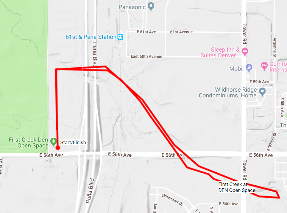
4. First Creek at DEN Trail (4 miles)
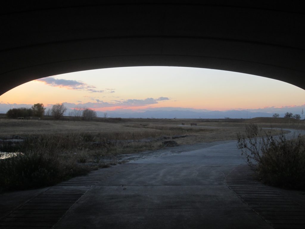
I can’t write about this unknown trail enough (see video of First Creek at DEN.) It opened in 2018, and it is such a treasure. If you are on the way to or from the airport, it is a perfect way to unwind and experience this natural prairie that is home to coyotes, hawks, owls, black-tailed prairie dogs, deer, and even eagles. Although the first 1/3 mile is on the abandoned Old Buckley Road next to the Rocky Mountain Arsenal Wildlife Refuge, the down-n-back along a concrete path next to the First Creek is a refreshing, shady oasis under a cottonwood canopy. The best time to do this hike is sunrise or sunset. You’ll catch many birds of prey, the alpen glow in the morning, or a Rockies sunset in the evening. I absolutely love this trail.
Turn-by-turn directions. Park at the intersection of 56th Ave and Pena Blvd. Walk north on the abandoned Old Buckley Road about 1/3 mile to the trailhead on the right (if you go a bit more, you’ll find another trailhead on the left into the Wildlife Refuge. But this isn’t shady.) Go to the right on the concrete path. Walk 2 miles. The trail ends just past the underpass for the A Train as you enter First Creek Park. Turn around and retrace your steps. Be sure to bring water and snacks!
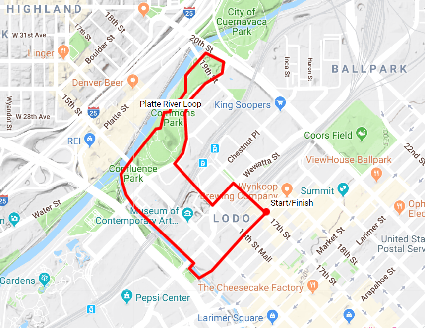
5. The Platte River Downtown Loop. (3-4 Miles)
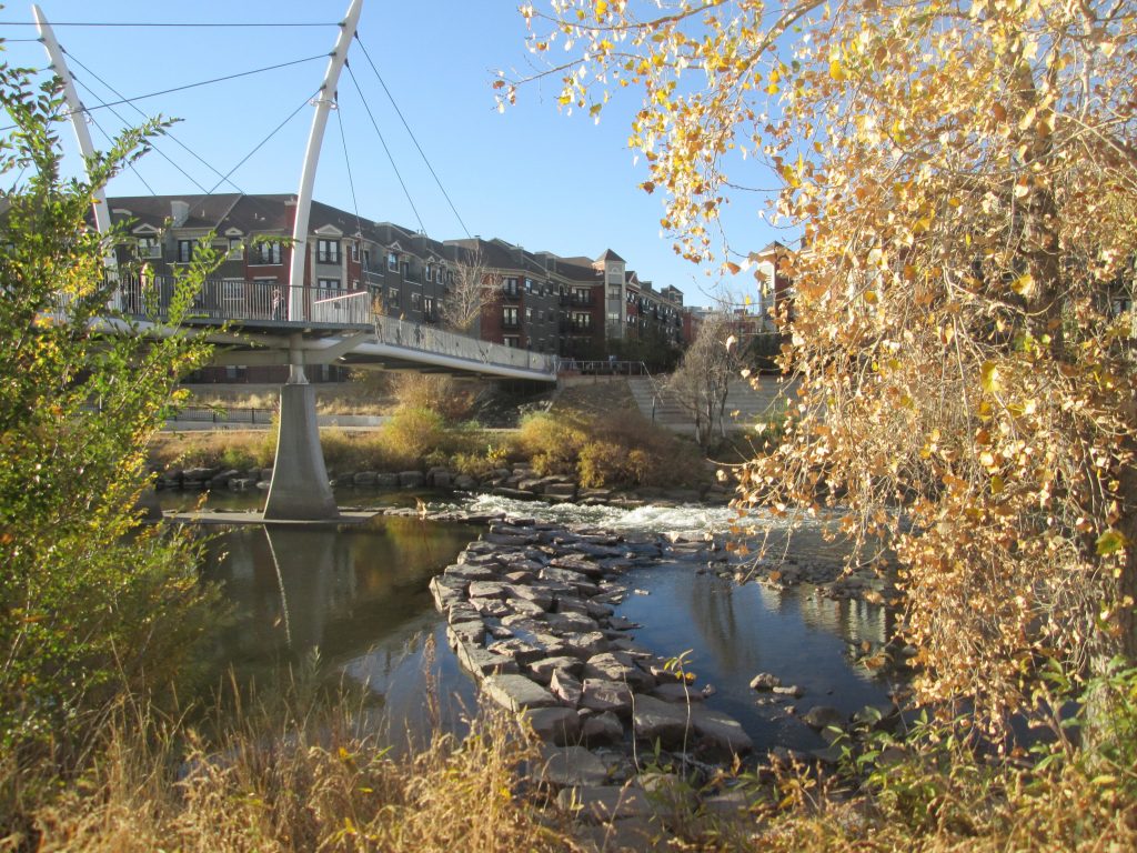
Another hike I can never get enough of is what I call the Platte River Loop. With plenty of activity to keep you entertained along the way, if you stay on the east side of the River, there is generally a good amount of shade to protect you on hot days. Combined with enjoying the fun Union Station and Confluence (see video) downtown areas, I take visitors on this hike often. Afterward, we will grab a bite or at least an ice cream at Union Station.
Turn-by-turn directions. Start at Union Station by taking transit into town. Exit Union Station on Wynkoop heading toward 16th St. Stay on Wynkoop until you get to the Cherry Creek Trail, which you’ll access with the ramp. On Cherry Creek, turn right (west) toward the confluence with the Platte River. Walk the bend around the confluence, connecting with the Platte River Trail. Pay attention to bikes and stay to the right of the trail. You’ll pass through Commons Park (see video.) Stay on the Platte River as long as you’d like. I like to go at least to Denver Skate Park (see video.)
At the Skate Park, exit the trail, then make your way back toward downtown within Commons Park on the concrete path. Enjoy the many pieces of public sculpture and historical interpretation. You’ll eventually reach the 16th Street pedestrian bridge, a large, white, suspension bridge. Take the stairs up and over the railroad tracks, dropping you down onto Wewatta Street. Take a left and return to the Union Station transit area.
Finding Shaded Hikes in Denver

I admit. Finding shaded hikes IN Denver isn’t easy. But here are five. What would you recommend? Got any secret, shady spots for a good hike IN the City and County of Denver? Fess up. Tag them #denverbyfoot so I can see. I’ll share and repost! Thanks!
See you on the trail!
Follow us on Instagram and Facebook to keep updated with new hikes and adventures.
Trackbacks/Pingbacks